

How my small home town was once regarded as one of the most important places in the world.
Having an interest in travel means I also have an interest in maps: the ongoing progression and evolution of how our planet is perceived. It’s amazing to think that at one time people’s knowledge of the earth was not so different than our own perception of space today: not exactly knowing what was out there. This curiosity drove explorers to go beyond the reaches of where man had ever been before; a fearlessness that ultimately resulted in the (semi) accepted world map we take for granted today.

Where Bangor sits on the Mercator projection of the world
Early maps of the world were, of course, riddled with inaccuracies. In ancient China, the prevailing belief was that the Earth was flat and square, while the heavens were round, an assumption virtually unquestioned until the introduction of European astronomy in the 17th century. Medieval maps placed Africa at the edge of the known world, portraying it as a hellish place filled with gruesome, grotesque monsters. The most famous of all these medieval maps is the Hereford mappa mundi – the largest medieval map known still to exist in the world today.
The Hereford Mappa Mundi
Drawn at the close of the 13th century on a single calfskin, the Hereford mappa mundi has survived 700 years and is now one of the most significant historical maps in the world. In places it is surprisingly accurate, in others, shockingly off base. It is also full of curious anomalies – from mysterious animals and Biblical scenes to events from classical mythology. In total, the map includes around 500 illustrations of people, places, animals, cities and towns.

The Hereford mappa mundi. The UK and Ireland is highlighted in red. (Click to enlarge.)
East is at the top of the map, South is on the right, West is at the bottom with North on the left. At the centre of the Mappa Mundi is Jerusalem, the centre of the Christian world. The continents are illustrated with drawings of cities and towns, with important landmarks such as The Ganges, Egypt, Sri Lanka, Greece with Mt. Olympus, and The Strait of Gibraltar (seen as the Pillars of Hercules).
And right down at in the bottom of the map, among all these heavyweights, is Bangor.

UK and Ireland with place names in Norman French & Latin
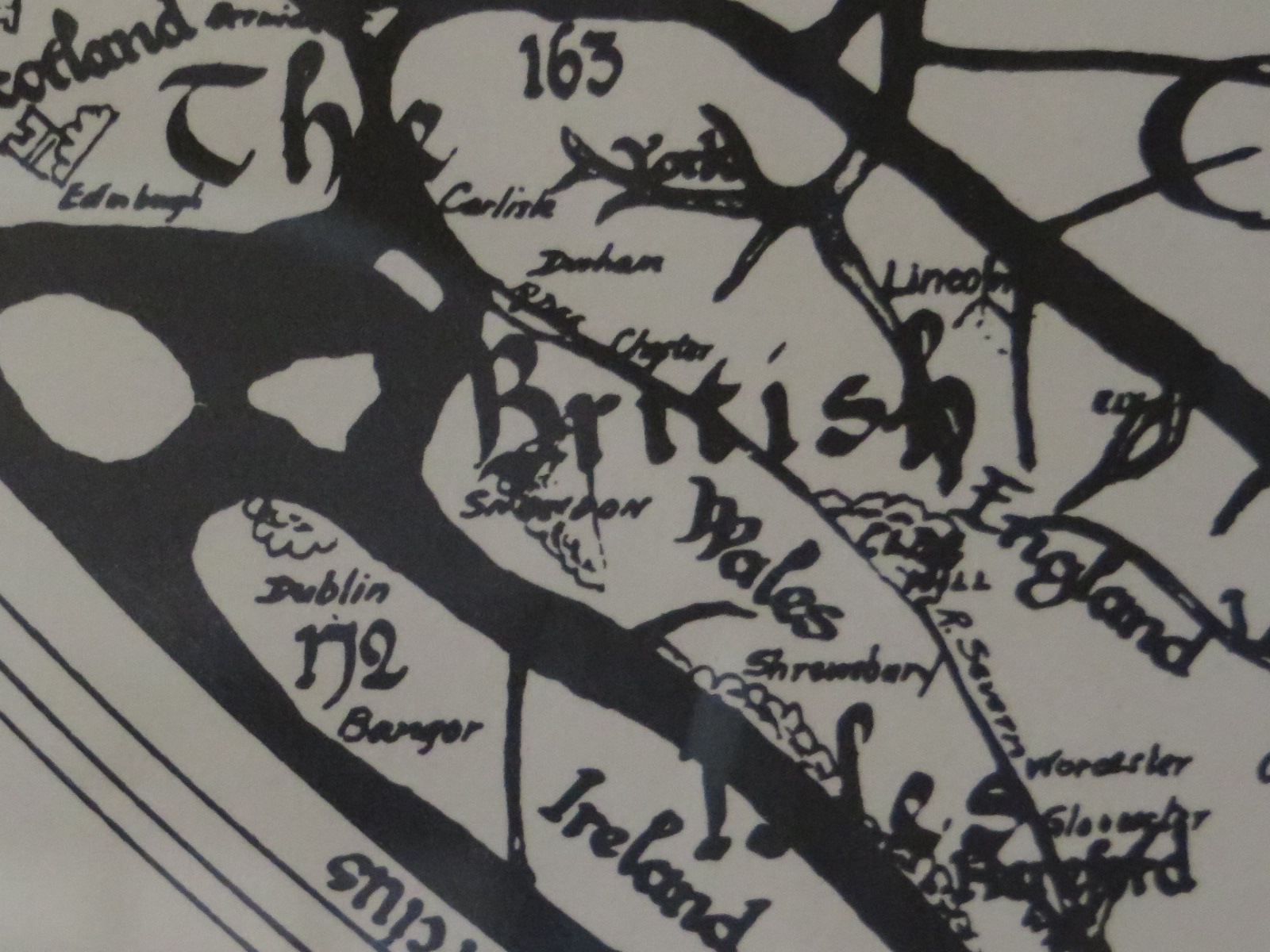
Translation of the same area, with Bangor featured alongside Dublin.
Bangor? Really?
Yes, Bangor is featured on the largest medieval map known still to exist in the world today. Belfast isn’t even mentioned. For anyone unfamiliar with my home town, it’s in Northern Ireland and has a population of just 60,000. Upon first glance it certainly doesn’t seem befitting of this recognition, but the reason is because of Bangor Abbey which sits at the centre of the town and just two minutes from my house.

Bangor Abbey
The monastery of Bangor was founded by Saint Comgall in approximately 555 and grew to be a centre of great learning – becoming one of the most eminent missionary institutions in Europe in the Early Middle Ages. During the 8th and 9th century the town was ravaged by Viking raiders and virtually became a ghost town – but when Saint Malachy was elected Abbot of the monastery in 1123, his extensive travels around Europe inspired him to rejuvenate the monasteries in Ireland including Bangor.
IKIMASHO!
I realise this post will be of little interest or significance to anyone outside of my home town. But I think it just goes to show that no matter how nondescript a town may seem now, there’s no telling just how important it may have been in the past. So the next time you are walking through a small town or village on your travels thinking somewhere doesn’t seem impressive or important, don’t write it off just yet. You never know what it once was.
Like IKIMASHO! on Facebook

Is that the M2 mentioned just above Bangor? A very important road that.
You said it will be of little interest to non-Bangorians (if that is the word) but actually I think it is interesting to pick up these odd bits of information, not for any logical reason but just for enjoyment.
Glad you found it interesting Richard! It’s funny the places and things you take for granted. That Abbey has been round the corner from me all my life growing up but you don’t really think about how things may have been hundreds of years ago… mad to think of Vikings running about and all!
And Bangorians is the right term indeed 🙂
Pingback: When only the streets remain. Bangor, Northern Ireland. | Ikimasho!
Pingback: From Bangor to the world: The Hereford Mappa Mundi. | taboggantimes
Interesting article. Never seen maps like that before. Great read
Miss Rodgers faithfully taught us the Bangor History to which you refer. I for one was captivated… Sometime between 1953 and 1956 whilst a pupil at Bangor Collegiate School (before the amalgamation with Bangor Glenlola-Collegiate, which then became Glenlola-Collegiate. I did not know about the Bangor entry in the Hereford Mappa Mundi. Thank you for your posting
Lovely, informative and well written posts. A breath of fresh air instead of the usual moany comments/posts.
Thanks vey much.
Thank you for this post! I learned something new today, which is one if my favorite things in life thanks to you. It’s very interesting and it brightened my evening.
Thank you so much for the kind comment!